Mapping Underground, Scanning the Toughnut Mine in Tombstone, Arizona
- Nathan Robinson, RLS
- Jan 28
- 4 min read

The Arizona Young Surveyors Network went back to Tombstone this past year with a wild plan, gather Arizona's young surveyors and send them underground in an 1800's silver mine! This mission was daunting for some, and exciting for others. Most of us had never been in an underground mine, let alone sent into one to make a map! The goal was simple, 3D scan the Toughnut Mine inside and out. In reality however, the task was no small feat.
As the rising sun began its rapid climb from behind the shaded mountains a crew began its climb up Comstock Hill just west of Tombstone. They climbed to the top and set up their GPS base on the NGS monument. They needed to establish ground control outside of the mine in order to bring everything into the real world. Two control points were set, a gun station and backsight. Then four aerial panels were set, this would be for the aerial mapping missions that would take place later. With panels tied, Will Wing with Infinity Land Surveying deployed his DJI drone and conducted a photogrammetry mission overhead, snapping some group photos along the way. Then from the initial gun station, Will set his Trimble SX12 up and conducted a dense scan of the mines entrance and surrounding area. Once that was complete two teams branched off. Team 1 would go with CEC and their Trimble X7 scanner into the large chamber in the bottom of the Toughnut mine, team 2 would start at the entrance with Diamondback LS's Trimble X7. The goal was to meet in the middle.
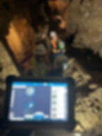
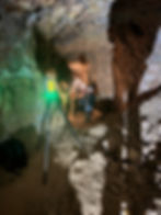
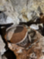
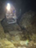
Team 1 made their way into the mine, winding through the tight tunnels carved over 120 years prior. Portions of this mine had water dripping off the ceiling and onto the teams hardhats. A variety of lights shot through the dark, some mounted on hardhats some in the teams hands. Fortunately, the team was led by expert mine explorer Andrew Keepers, who had spent countless hours ensuring this very mine was both structurally sound and safe to explore. The adit wove back and forth, with drifts branching off left and right. Without knowing the correct path one could have easily been lost. As team 1 approached the main hall at the bottom they were met with a ladder to climb down. One at a time they carefully climbed down and transferred their equipment into the chamber. This chamber was far bigger than any of them had envisioned, and was illuminated by dim lights scattered throughout, creating a chilling ambiance. Their guide Andrew gave them a quick orientation tour so they could grasp the real size of this space. Then they got to work, scan station after scan station. Over 20 scan stations to be exact! Constantly moving and working, deploying large flood lights the team had packed in to ensure high quality photos along with the scan. For many this was their first time running a scanner, and everyone got hands on experience.
Back on the surface team 2 was facing unforeseen troubles while running scans. The initial scan into the mines entrance worked fine, as did the second station. Then, came the issue they did not foresee. The scanner needs sharp, definitive objects to associate scans together. As team 2 worked down into the winding tunnel the walls became slick, with no sharp corners or shapes for the X7 to pick up. The team realized they would have to run control from the entrance all the way down through the tunnel system. This was not a task the team was prepared to accomplish this trip. It was decided this task would be left for the next visit in 2026, and team 2 made their way to the main chamber to work with team 1.
Down in the main chamber team 1 was making short work of the massive space. Team 2 joined them, led by the owner of the mine, Robert. Now whole again and with scanning winding down, the group gathered in the theatre hall of the main chamber. This was a portion of the chamber where a large body of ore was removed, creating a vaulted ceiling. Andrew and Robert then enhanced the room to create perfect acoustics for giving theatre performances. The teams gathered here as Andrew and Robert gave a detailed history of The Toughnut Mine. They spoke of how Tombstone came to be, how miners chased veins of silver ore deep underground, and how those veins they chased run right under the historic town itself. The teams then made their final scans of the entrance to the main chamber, with the same scanning issues happening as soon as they entered the narrow tunnel above the entrance ladder.
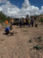
Once all the surveyors and guides made it back to the surface, Kris Brandt with Frontier Precision, busted out the big guns, the Freefly drone with LiDAR scanner. Kris conducted a LiDAR scan of the whole surface surrounding the mine, helping gather ground data even under brush and canopy. The group all got to learn how the drone works, and even fly it if they so chose. In real time the data was processed and passed on to be added to the teams database. This led to the groups closing event, catered lunch on the tailgate. They all gathered one last time for the day to break bread and share stories from their vast surveying backgrounds. The surveyors exchanged contact information, swapped photos they had taken while underground, then mounted up and got out of dodge. Bringing a close to the 2025 Arizona Young Surveyors Network Tombstone trip.
This monumental event could not have happened if not for the AZYSN's generous sponsors listed below, we at AZYSN thank them for supporting the next generation of surveyors.
-Arizona Professional Land Surveyors
-APLS Central Chapter
-APLS Yavapai Chapter
-ALTA Arizona
-Rick Engineering
-Coe & Van Loo Consultants
-Civil & Environmental Consultants, Inc.
With special thanks to those companies who came out and provided not only their equipment but their time to see the AZYSN succeed.
-Infinity Land Surveying
-Diamondback Land Surveying
-Civil & Environmental Consultants, Inc.
-Frontier Precision